|
Vikidia currently has 4,626 articles. Improve it! |
|
Join Vikidia: create your account now and improve it! |
File:Spanish America XVIII Century (Most Expansion).png
Jump to navigation
Jump to search


Size of this preview: 439 × 599 pixels. Other resolutions: 176 × 240 pixels | 352 × 480 pixels | 749 × 1,022 pixels.
Original file (749 × 1,022 pixels, file size: 77 KB, MIME type: image/png)
.png)
Summary
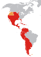
| Description | Mapa de la América española a finales del siglo XVIII / Map of Spanish America (XVIII century) |
| Date | |
| Source | Own work |
| Author | Jluisrs |
Leyenda
Mapa del es:Imperio Español en América a finales del siglo XVIII en su máxima expansión en ese continente.
- En rojo, los virreinatos y demás colonias.
- En amarillo oscuro, territorios disputados o reclamados por España.
Legend
Map of the w:Spanish Empire in America in the XVIII century.
- In red, Spanish posessions.
- In orange, reclamations and posessions where the Spanish had de jure authority only.
Licensing
| I, the copyright holder of this work, release this work into the public domain. This applies worldwide. In some countries this may not be legally possible; if so: I grant anyone the right to use this work for any purpose, without any conditions, unless such conditions are required by law. |
File history
Click on a date/time to view the file as it appeared at that time.
| Date/Time | Thumbnail | Dimensions | User | Comment | |
|---|---|---|---|---|---|
| current | 22:37, 22 April 2007 | | 749 × 1,022 (77 KB) | wikimediacommons>Jluisrs | {{Information |Description= Mapa de la América española a finales del siglo XVII / Map of Spanish America (XVIII century) |Source=self-made |Date= 22-4-2007 |Author= Jluisrs }} |
File usage
The following page uses this file:
.png)