Vikidia currently has 4,626 articles. Improve it!

Join Vikidia: create your account now and improve it!

File:Precision Farming in Minnesota - Natural Colour (part).jpg

From Vikidia, the encyclopedia for 8 to 13-year-old children that everybody can make better
Jump to navigation Jump to search

Precision_Farming_in_Minnesota_-_Natural_Colour_(part).jpg(720 × 480 pixels, file size: 523 KB, MIME type: image/jpeg)

This file is from Wikimedia Commons and may be used by other projects. The description on its file description page there is shown below.

Description
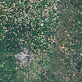
English: On September 10, 2009, Landsat scanned this true-color image of farmland across northwest Minnesota, including a view of Noreen Thomas' organic farm on the banks of the Buffalo River near the middle of the image. From space this farm looks like a patchwork quilt. Fields change hue with the season and with the alternating plots of organic wheat, soybeans, corn, alfalfa, flax, or hay. Lush green fields dominate the image, though some crops have already been harvested leaving squares of tan and brown.
Date
Source

moorhead_tm5_2009253.jpg (linked from "Precision Farming in Minnesota")

Image created using Landsat data provided by the United States Geological Survey; Instrument: Landsat 5 - TM.
Author NASA Earth Observatory, Jesse Allen
Permission
(Reusing this file)
Public domain This file is in the public domain in the United States because it was solely created by NASA. NASA copyright policy states that "NASA material is not protected by copyright unless noted". (See Template:PD-USGov, NASA copyright policy page or JPL Image Use Policy.)
Warnings:
Other versions

Captions

Add a one-line explanation of what this file represents

Items portrayed in this file

depicts

18 September 2009

image/jpeg

File history

Click on a date/time to view the file as it appeared at that time.

Date/TimeThumbnailDimensionsUserComment
current17:50, 28 June 2010Thumbnail for version as of 17:50, 28 June 2010720 × 480 (523 KB)wikimediacommons>Bdk{{Information |Description={{en|1=On September 10, 2009, Landsat scanned this true-color image of farmland across northwest Minnesota, including a view of Noreen Thomas' organic farm on the banks of the Buffalo River near the middle of the image. From

The following page uses this file: