|
Vikidia currently has 4,626 articles. Improve it! |
|
Join Vikidia: create your account now and improve it! |
File:Map of Territorial Growth 1790 sm.jpg
Jump to navigation
Jump to search


Size of this preview: 461 × 599 pixels. Other resolutions: 184 × 240 pixels | 369 × 480 pixels | 923 × 1,200 pixels.
Original file (923 × 1,200 pixels, file size: 91 KB, MIME type: image/jpeg)

|
This historical map image could be re-created using vector graphics as an SVG file. This has several advantages; see Commons:Media for cleanup for more information. If an SVG form of this image is available, please upload it and afterwards replace this template with
{{vector version available|new image name}}.
It is recommended to name the SVG file “Map of Territorial Growth 1790 sm.svg”—then the template Vector version available (or Vva) does not need the new image name parameter. |


Transwiki approved by: w:en:User:Dmcdevit
This image was copied from wikipedia:en. The original description was:
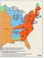
This map was obtained from an edition of the National Atlas of the United States. Like almost all works of the U.S. federal government, works from the National Atlas are in the public domain in the United States.
Online access: NationalAtlas.gov | 1970 print edition: Library of Congress, Perry-Castañeda Library
|
w:en:Category:National Atlas territorial expansion maps
Original upload log
| date/time | username | resolution | size | edit summary |
|---|---|---|---|---|
| 12:56, 3 March 2004 | w:en:User:Bkonrad | 923×1200 | 91 KB | Map of U.S. Territorial Growth 1790 |
Image description page history
File history
Click on a date/time to view the file as it appeared at that time.
| Date/Time | Thumbnail | Dimensions | User | Comment | |
|---|---|---|---|---|---|
| current | 17:29, 10 September 2007 | | 923 × 1,200 (91 KB) | wikimediacommons>BetacommandBot | Transwiki approved by: w:en:User:Dmcdevit This image was copied from wikipedia:en. The original description was: {{badJPEG}} {{PD-USGov-Atlas}} w:en:Category:National Atlas territorial expansion maps === File history === {| class=wikitable ! d |
File usage
The following page uses this file: