|
Vikidia currently has 4,636 articles. Improve it! |
|
Join Vikidia: create your account now and improve it! |
File:Volcano Map.png
Jump to navigation
Jump to search
No higher resolution available.
Volcano_Map.png (611 × 273 pixels, file size: 22 KB, MIME type: image/png)
Summary
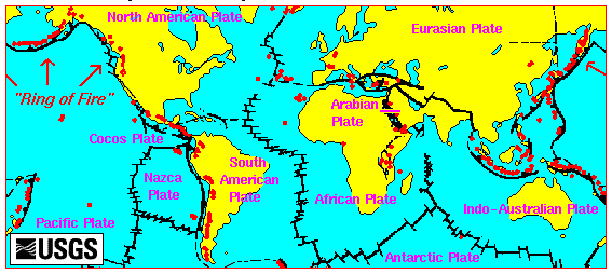
English: Volcano Map from the USGS site.
Licensing
This image is in the public domain in the United States because it only contains materials that originally came from the United States Geological Survey, an agency of the United States Department of the Interior. For more information, see the official USGS copyright policy.
|
File history
Click on a date/time to view the file as it appeared at that time.
| Date/Time | Thumbnail | Dimensions | User | Comment | |
|---|---|---|---|---|---|
| current | 19:14, 29 September 2008 | | 611 × 273 (22 KB) | wikimediacommons>Rvd4life | Volcano Map {{PD-USGov-Interior-USGS}} <!--{{ImageUpload|basic}}--> |
File usage
The following page uses this file: