|
Vikidia currently has 4,627 articles. Improve it! |
|
Join Vikidia: create your account now and improve it! |
File:Languages of the Americas.PNG
Jump to navigation
Jump to search


Size of this preview: 541 × 599 pixels. Other resolutions: 217 × 240 pixels | 624 × 691 pixels.
Original file (624 × 691 pixels, file size: 23 KB, MIME type: image/png)

| Description |
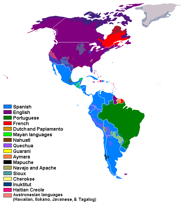
English: Languages of the Americas Español: Lenguas de América |
| Date | (UTC) |
| Source | |
| Author |
|
| This is a retouched picture, which means that it has been digitally altered from its original version. Modifications: Translated using the wonderful service of Wiktionary.. The original can be viewed here: Idiomas de américa.png:
|
I, the copyright holder of this work, hereby publish it under the following licenses:
This file is licensed under the Creative Commons Attribution-Share Alike 3.0 Unported, 2.5 Generic, 2.0 Generic and 1.0 Generic license.
- You are free:
- to share – to copy, distribute and transmit the work
- to remix – to adapt the work
- Under the following conditions:
- attribution – You must give appropriate credit, provide a link to the license, and indicate if changes were made. You may do so in any reasonable manner, but not in any way that suggests the licensor endorses you or your use.
- share alike – If you remix, transform, or build upon the material, you must distribute your contributions under the same or compatible license as the original.

|
Permission is granted to copy, distribute and/or modify this document under the terms of the GNU Free Documentation License, Version 1.2 or any later version published by the Free Software Foundation; with no Invariant Sections, no Front-Cover Texts, and no Back-Cover Texts. A copy of the license is included in the section entitled GNU Free Documentation License. |
You may select the license of your choice.
Original upload log
This image is a derivative work of the following images:
- File:Idiomas_de_américa.png licensed with Cc-by-sa-3.0,2.5,2.0,1.0, GFDL
- 2008-12-31T10:43:48Z Hidra92 624x691 (10662 Bytes) {{Information |Description={{en|1=Languages of America}} {{es|1=Lenguas de América}} |Source=trabajo propio (own work) |Author=[[User:Hidra92|Hidra92]] |Date=31-12-08 |Permission= |other_versions= }}
Uploaded with derivativeFX
File history
Click on a date/time to view the file as it appeared at that time.
| Date/Time | Thumbnail | Dimensions | User | Comment | |
|---|---|---|---|---|---|
| current | 05:34, 10 May 2015 | | 624 × 691 (23 KB) | wikimediacommons>Zorion | Improvement for Canada (added French from Hearst to Abitibi + Anticosti + part of New-Brunswick) + (Turn French into English in Labrador and part of New-Brunswick)) |
File usage
The following page uses this file: