|
Vikidia currently has 4,621 articles. Improve it! |
|
Join Vikidia: create your account now and improve it! |
File:Panama-Canal-rough-diagram-quick.jpg
Panama-Canal-rough-diagram-quick.jpg (560 × 540 pixels, file size: 57 KB, MIME type: image/jpeg)
Summary
| Description |
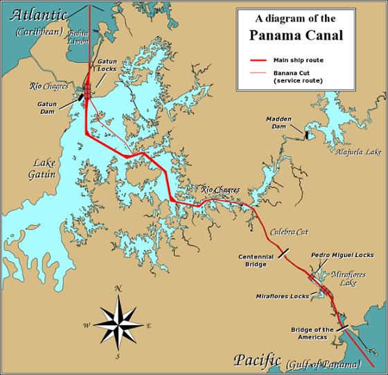
English: A diagram illustrating the layout of the Panama Canal (in quick JPEG format, auto-resizes to fit).
Due to the shape of the Isthmus of Panama, the Pacific end of the canal is actually the south-east end, and the Caribbean / Atlantic end is at the north-west. From the Pacific side, the Miraflores and Pedro Miguel locks (with two and one stages respectively) lead up to the highest level of the canal, 26 metres (85 feet) above sea level. The Culebra Cut (or Gaillard Cut) leads to Gatún Lake, created by damming the Chagres River; then the Gatún Locks lead back down to sea level in Limón Bay. The heavy red line shows the ship route. The narrower red line in Gatún Lake is the Banana Cut, a shortcut used by canal boats and yachts. |
| Date | |
| Source | Source URL: Image:Panama_Canal_Rough_Diagram.png (GFDL file, reduced/retouched, saved JPEG format (5x faster than PNG), intended for use in frequently-read Wiki articles). |
| Author | User:Johantheghost (JPEG version by Wikid77) |

|
This transport map image could be re-created using vector graphics as an SVG file. This has several advantages; see Commons:Media for cleanup for more information. If an SVG form of this image is available, please upload it and afterwards replace this template with
{{vector version available|new image name}}.
It is recommended to name the SVG file “Panama-Canal-rough-diagram-quick.svg”—then the template Vector version available (or Vva) does not need the new image name parameter. |


Licensing

|
Permission is granted to copy, distribute and/or modify this document under the terms of the GNU Free Documentation License, Version 1.2 or any later version published by the Free Software Foundation; with no Invariant Sections, no Front-Cover Texts, and no Back-Cover Texts. A copy of the license is included in the section entitled GNU Free Documentation License. |
| This file is licensed under the Creative Commons Attribution-Share Alike 3.0 Unported license. | ||
| ||
| This licensing tag was added to this file as part of the GFDL licensing update. |
File history
Click on a date/time to view the file as it appeared at that time.
| Date/Time | Thumbnail | Dimensions | User | Comment | |
|---|---|---|---|---|---|
| current | 19:28, 26 December 2006 | | 560 × 540 (57 KB) | wikimediacommons>Wikid77 | == Summary == A diagram illustrating the layout of the Panama Canal (in quick JPEG format, auto-resizes to fit). Due to the shape of the Isthmus of Panama, the Pacific |
File usage
The following page uses this file: