|
Vikidia currently has 4,625 articles. Improve it! |
|
Join Vikidia: create your account now and improve it! |
File:GardenStreetBridgeSchuylkillRiverSkylinePhiladelphiaPennsylvania.jpg
Jump to navigation
Jump to search


Size of this preview: 799 × 191 pixels. Other resolutions: 320 × 77 pixels | 640 × 153 pixels | 1,024 × 245 pixels | 1,280 × 306 pixels | 2,560 × 613 pixels | 10,000 × 2,393 pixels.
Original file (10,000 × 2,393 pixels, file size: 16.85 MB, MIME type: image/jpeg)
|
This image has been assessed using the Quality image guidelines and is considered a Quality image.
|
Summary
| Description |
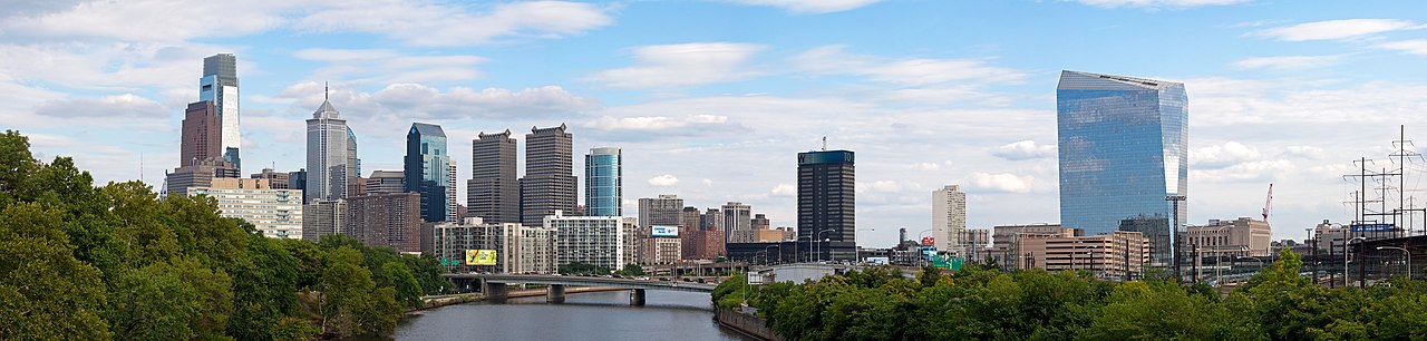
English: The skyline of Pennsylvania's largest city Philadelphia. Visible are Center City with the Comcast Center on the left bank of the Schuylkill River and the 30th Street Station with the Cira Centre on the right. The resolution of the original photograph is 15000*3597.
Nederlands: De skyline van de grootste stad in de staat Pennsylvania Philadelphia. Zichtbaar zijn Center City met het Comcast Center op de linker oever van de Schuylkill Rivier en het 30th Street Station met het Cira Centre op de rechter oever. De resolutie van de oorspronkelijke foto is 15000*3597. |
| Date | |
| Source | Own work |
| Author | Massimo Catarinella |
| Permission (Reusing this file) |
See license, attribution required - contact me to discuss less restrictive commercial licensing terms by email Special:EmailUser/Massimo Catarinella or leave a message on my talk page |
| Other versions |
Derivative works of this file:
  |
_cropped.jpg)
| Camera location | | View this and other nearby images on: OpenStreetMap |
|---|
Licensing
I, the copyright holder of this work, hereby publish it under the following license:
This file is licensed under the Creative Commons Attribution 3.0 Unported license.
- You are free:
- to share – to copy, distribute and transmit the work
- to remix – to adapt the work
- Under the following conditions:
- attribution – You must give appropriate credit, provide a link to the license, and indicate if changes were made. You may do so in any reasonable manner, but not in any way that suggests the licensor endorses you or your use.
File history
Click on a date/time to view the file as it appeared at that time.
| Date/Time | Thumbnail | Dimensions | User | Comment | |
|---|---|---|---|---|---|
| current | 01:06, 25 August 2009 | 10,000 × 2,393 (16.85 MB) | wikimediacommons>Massimo Catarinella | sRGB |
File usage
The following page uses this file: