|
Vikidia currently has 4,621 articles. Improve it! |
|
Join Vikidia: create your account now and improve it! |
File:France cities.png
Jump to navigation
Jump to search

Size of this preview: 600 × 600 pixels. Other resolutions: 240 × 240 pixels | 480 × 480 pixels | 768 × 768 pixels | 1,025 × 1,024 pixels | 1,797 × 1,796 pixels.
Original file (1,797 × 1,796 pixels, file size: 3.53 MB, MIME type: image/png)
| Description |
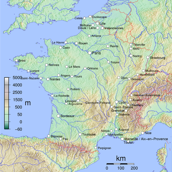
English: Map of Metropolitan French cities (agglomerations > 100,000 inhabitants on 1999 census).
Français : Carte des villes de la France métropolitaine (agglomérations de plus 100 000 habitants au recensement de 1999). See Image:France cities.pdf. |
||||||||
| Date | |||||||||
| Source | Own work | ||||||||
| Author | David Monniaux | ||||||||
| Permission (Reusing this file) |
This file is licensed under the Creative Commons Attribution-Share Alike 2.0 Generic license.
This file is licensed under the Creative Commons Attribution-Share Alike 2.0 France license.
 |
||||||||
| Other versions |
|

|
This image was selected as picture of the day on Wikimedia Commons for 6 April 2006. It was captioned as follows: Other languages:
Čeština: Mapa ukazující polohu velkých francouzských měst (nad 100 000 obyvatel). Deutsch: Karte der französischen Großstädte Français : Carte des villes de France métropolitaine de plus de 100 000 habitants Galego: Mapa de Francia Italiano: Carta delle città francesi con più di 100.000 abitanti Magyar: 100000-nél több lakosú francia nagyvárosok térképe Norsk nynorsk: Kart over Frankrike, der byar med over 100 000 innbyggjarar er merkte av. Polski: Największe miasta Francji (powyżej 100.000 mieszkańców) Português: Mapa da França Svenska: Frankrike-karta där städer med över 100 000 invånare är utsatta. Русский: Крупнейшие города Франции ไทย: แผนที่แสดงนครในประเทศฝรั่งเศสส่วนกลาง (la France métropolitaine) 日本語: フランスの主要都市を記した地図 中文: 法国十万人以上城市位置图 |
File history
Click on a date/time to view the file as it appeared at that time.
| Date/Time | Thumbnail | Dimensions | User | Comment | |
|---|---|---|---|---|---|
| current | 12:30, 17 April 2007 | | 1,797 × 1,796 (3.53 MB) | wikimediacommons>Tene~commonswiki | Optimised (5) |
File usage
The following page uses this file: