|
Vikidia currently has 4,621 articles. Improve it! |
|
Join Vikidia: create your account now and improve it! |
File:Flusssystemkarte Rhein 04.jpg
Jump to navigation
Jump to search


Size of this preview: 441 × 599 pixels. Other resolutions: 177 × 240 pixels | 353 × 480 pixels | 565 × 768 pixels | 754 × 1,024 pixels | 1,508 × 2,048 pixels | 3,198 × 4,344 pixels.
Original file (3,198 × 4,344 pixels, file size: 11.72 MB, MIME type: image/jpeg)
Summary
| Description |
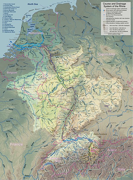
English: Rhine course and river system, place names in English Deutsch: Rheinlauf und Flusssystem, englisch beschriftet Français : Cours du Rhin et son bassin versant, noms de lieux en anglais Nederlands: Verloop en rivierensysteem van de Rijn, plaatsnamen in Engels |
| Date | |
| Source | Own work |
| Author | WWasser |
| Other versions | Versions in german, french, dutch, or with local names. For other languages the unlabelled version may be used. There are also less detailed maps of the river system with either german, english, french, dutch, or local names. A small version without names is available, too. |
| Camera location | | View this and other nearby images on: OpenStreetMap |
|---|
- Background relief created with Google Maps-For-Free SRTM3 Webserver
- Topography derived from Open Street Map
- Outlines of catchment areas derived from relief data (in the Netherlands also taken from several ICPR (International Commission for the Protection of the Rhine)- and Rijkswaterstaat-publications)
Licensing
I, the copyright holder of this work, hereby publish it under the following license:
This file is licensed under the Creative Commons Attribution-Share Alike 3.0 Unported license.
- You are free:
- to share – to copy, distribute and transmit the work
- to remix – to adapt the work
- Under the following conditions:
- attribution – You must give appropriate credit, provide a link to the license, and indicate if changes were made. You may do so in any reasonable manner, but not in any way that suggests the licensor endorses you or your use.
- share alike – If you remix, transform, or build upon the material, you must distribute your contributions under the same or compatible license as the original.
File history
Click on a date/time to view the file as it appeared at that time.
| Date/Time | Thumbnail | Dimensions | User | Comment | |
|---|---|---|---|---|---|
| current | 20:26, 17 September 2017 | | 3,198 × 4,344 (11.72 MB) | wikimediacommons>WWasser | Albertkanaal, Aa (Dommel), frontier lines in Lake of Constance |
File usage
The following page uses this file: