|
Vikidia currently has 4,621 articles. Improve it! |
|
Join Vikidia: create your account now and improve it! |
File:Continents vide couleurs.png
Jump to navigation
Jump to search

Size of this preview: 800 × 406 pixels. Other resolutions: 320 × 162 pixels | 640 × 325 pixels | 1,488 × 755 pixels.
Original file (1,488 × 755 pixels, file size: 48 KB, MIME type: image/png)
Summary
| Description |
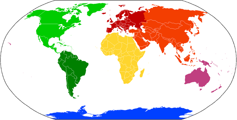
Deutsch: Karte der Kontinente, basierend auf File:BlankMap-World.png. Die Karte enthält keine Beschriftung, damit sie als Grundlage für verschiedene Sprachen benutzt werden kann. Kontinente, für die verschiedene Aufteilungen in Gebrauch sind (z.B. Amerika bzw. Nord-/Südamerika oder Eurasien bzw. Europa/Asien) sind in verschiedenen Abstufungen der selben Farbe gehalten.
English: Compiled chiefly from File:BlankMap-World.png. Blank to permit labels in various languages. Controversial continents/subcontinents (i.e. one or two Americas, Eurasia vs Europe and Asia) are in different shades of the same colour:
Français : Carte des continents, depuis File:BlankMap-World.png. C'est vide pour permettre aux gens d'ajouter des étiquettes propres à diverses langues. Les continents/sous-continents dont le statut est controversé (par exemple, une Amérique ou deux, Eurasie ou Europe et Asie) sont illustrés en teints différents de la même couleur.
Italiano: Carta dei continenti, basata su File:BlankMap-World.png. La carta non contiene descrizioni, in modo che possa essere utilizzata in ogni lingua. I continenti che sono spesso menzionati come diversi (ad esempio America e Nord/Sud Amerika) sono mostrati in diverse gradazioni dello stesso colore.
Polski: Mapa kontynentów, oparta na File:BlankMap-World.png. Nie zawiera żadnych nazw, aby można je było nanosić w różnych językach. Kontynenty, pomiędzy którymi granice są dyskusyjne (tzn. Ameryka Północna i Południowa, Europa i Azja) oznaczono różnymi odcieniami tych samych kolorów. |
||||||||
| Source | File:BlankMap-World.png | ||||||||
| Author | User:Cogito ergo sumo | ||||||||
| Permission (Reusing this file) |
I, the copyright holder of this work, hereby publish it under the following licenses:
This file is licensed under the Creative Commons Attribution-Share Alike 2.5 Generic, 2.0 Generic and 1.0 Generic license.
You may select the license of your choice. |
||||||||
| Other versions |
Derivative works of this file: Continents vide couleurs-automatedvector.svgDerivative works of this file: Continents vide couleurs 2.png |


File history
Click on a date/time to view the file as it appeared at that time.
| Date/Time | Thumbnail | Dimensions | User | Comment | |
|---|---|---|---|---|---|
| current | 10:54, 11 April 2022 | | 1,488 × 755 (48 KB) | wikimediacommons>Giorgi Balakhadze | rv of sockpuppet |
File usage
The following page uses this file: